Coastkeeper Provides Chart for Boaters and Divers
Byline: Ambrosia Brody
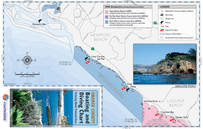
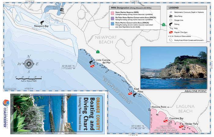
NEWPORT BEACH — Mariners can now refer to Orange County Coastkeeper’s newly released boating and diving chart to help distinguish Marine Protected Areas (MPAs) from regions open to fishing and diving.
“We want them to know where the new MPAs are, and reduce confusion,” said Ray Hiemstra, associate director for Orange County Coastkeeper. “We don’t want people to think they can’t do anything between Newport Beach and Dana Point, because that is nowhere near the way it is.”
Using Abalone Point and Table Rock in as the two main boundaries, the chart depicts open fishing spots in Newport Bay, Corona del Mar and Reef Point, along with popular diving spots. Kelp beds, state marine reserve no-take zones and conservation areas are also shown on the chart — along with rocks and obstructions, rocky areas and danger lines.
“We are trying to de-emphasize the state marine conservation areas, because there are wide-open areas for fishing,” Hiemstra said.
The map was derived from information gathered from the first MPA Watch Program annual report. The 2012 report shares observational data gathered on the human uses surrounding MPAs, according to Coastkeeper. Volunteers completed 754 surveys and observed 44,670 activities — consumptive and non-consumptive, onshore and offshore.
MPAs along the Southern California coast have been in effect since Jan. 1, in areas from Point Conception to the California/Mexico border.
“There are several maps out there,” Hiemstra said. “What we wanted to do was make a simple, easy-to-use map for Orange County boaters, divers and offshore users.”
The chart uses the same symbols as the California Department of Fish and Wildlife, and National Oceanic and Atmospheric Association (NOAA) — making it easy to identify rock reefs and kelp beds. Popular fishing and diving spots are also identified on the map with symbols.
Boat launch ramps at Doheny and Newport Dunes are indicated on the map.
The free charts can be found at West Marine stores, dive shops, chandleries, tackle stores and sportfishing landings. Coastkeeper staff members and volunteers also hand out the maps at boat launch ramps.
The report and map can be found at coastkeeper.org/mpa-watch/.
Where to Find It
The Orange County Coastkeeper boating and diving chart can be found at the following locations:
Costa Mesa: Big 5, Glenn’s Rod N’ Gun, His and Her Fly Fishing, Minney’s Yacht Surplus.
Cypress: Beach Cities Scuba.
Dana Point: Beach Cities Scuba, West Marine, Dana Point Yacht Club, Riviera Yacht Charters, Dana Wharf Sportfishing.
Fountain Valley: Sports Authority.
Huntington Beach: REI, West Marine, Dick’s Sporting Goods, Beach Cities Scuba.
Irvine: Big 5, Sports Chalet, Dive and Photo.
Laguna Beach: Laguna Sea Sports.
Lake Forest: Sea Stallion Scuba Outfitters.
Newport Beach: Basin Marine, Davey Jones’ Locker, Balboa Angling Club, American Legion Yacht Club, West Marine, Hipp Marine, OCC School of Sailing and Seamanship, Newport Aquatic Center, Beach Cities Scuba, Newport Harbor Yacht Club
Santa Ana: Sports Authority.
Seal Beach: Big Fish.
Westminster: Coral Reef Wet Suits.


