
NOAA Proposes Chumash Heritage National Marine Sanctuary
NOAA has released the draft designation documents for the proposed Chumash Heritage National Marine Sanctuary for public comment. The action comes after the agency analyzed and evaluated feedback from the public, stakeholders, tribes and Indigenous communities, scientists and federal and state agencies. The proposed sanctuary designation stretches over 134 miles of coastline, enclosing more than 5,600 square miles of water off the Central California coast. It would advance President Biden’s America the Beautiful Initiative, which supports locally led conservation efforts nationwide to conserve and restore 30% of U.S. lands and waters by 2030.
The Chumash people are Native American inhabitants of the central and southern coastal regions of California, and they have a rich cultural and historical heritage in the area. Efforts to establish marine sanctuaries or protected areas that recognize and preserve the cultural and natural resources associated with indigenous communities are not uncommon.
According to NOAA, on behalf of a broad community consortium, the Northern Chumash Tribal Council submitted the sanctuary nomination in July 2015. NOAA’s Office of National Marine Sanctuaries issued a Notice of Intent to begin the designation process for the proposed sanctuary in November 2021. NOAA’s proposed designation would protect the region’s important marine ecosystems and maritime heritage resources, support ocean-dependent economies and highlight Indigenous communities’ cultural values and connections to the area. This proposed designation helps to manifest the Biden-Harris administration’s commitment to honoring Tribal Nations, respecting Indigenous knowledge and advancing co-stewardship.
NOAA’s proposal is as Follows:
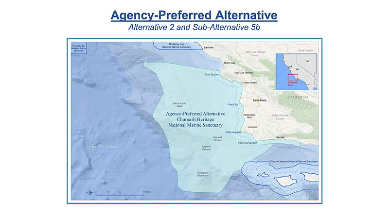
The boundary of the Agency-Preferred Alternative for the proposed sanctuary would stretch along 134 miles of coastline from Montaña de Oro State Park in San Luis Obispo County to Naples, Calif., along the Gaviota Coast in Santa Barbara County, and encompass 5,617 square miles. The preferred boundary differs from the initial proposed boundary in two important ways.
First, it includes a nearshore stretch of coastal waters along the Gaviota coast to include all of Gaviota State Park, as well as other high visitation state parks at Refugio and El Capitan, all of Kashtayit and Naples State marine conservation areas, and coastal and offshore resources adjacent to historical Chumash village sites at Tajiguas and Dos Pueblos.
Second, the preferred boundary excludes a wide area that could serve as a corridor for the industrial development associated with offshore wind energy production (specifically subsea electrical transmission cables and substations from the Morro Bay Wind Energy Area to shore), given that certain concentrations of this infrastructure may not be compatible with a national marine sanctuary depending on the number of cables and disturbances that could occur. The preferred boundary also allows NOAA to focus its management on key areas historically important to the Chumash tribes and natural resources important to their heritage.
The proposed sanctuary protects the incredible ecological qualities of the area. Within this area, temperate waters from the north meet warmer southern currents, and seasonal upwelling of nutrient-rich waters along the California Current fuel the food web, supporting a rich marine ecosystem. The area is recognized as a biological hotspot for birds, marine mammals, sea turtles, fish, other marine organisms and algae, like kelp. The area includes thriving ecological habitats such as kelp forests, rocky reefs and sandy beaches, as well as unique and important offshore geologic features like the Rodriguez Seamount, Santa Lucia Bank and Arguello Canyon, all home to unique and rare deep-sea coral and sponges. Importantly, the proposed sanctuary sits between existing marine protected areas, enhancing opportunities for ecological connectivity and protected corridors for fish and wildlife. It would be the first new sanctuary since 1994 that would be managed for biodiversity conservation as part of the National Marine Sanctuary System.
The draft management plan includes a framework for tribal and Indigenous collaborative management, providing a unique and special opportunity to involve, recognize and celebrate Indigenous peoples’ values, knowledge, traditions and modern day and cultural connections to the area. This region and its abundant resources have been home to coastal, ocean-going Indigenous tribes for tens of thousands of years. A sanctuary designation would promote partnerships with tribes and Indigenous communities interested in highlighting their culture and seeking to better understand and protect ancient village sites that may exist along the now-submerged paleo shoreline. Tribal and Indigenous community members would have opportunities to join in sanctuary decision-making processes and cultural programming through the sanctuary’s advisory council, working groups of the advisory council, a new Intergovernmental Policy Council and joint project agreements. Input from local area tribes and Indigenous communities was integral to the development of the draft framework and NOAA will continue to seek their ideas and assistance during the next steps of the designation process. In total, NOAA is proposing 11 action plans within the draft management plan, ranging from Indigenous cultural heritage to climate change.
Sanctuary designation would come with some regulations that protect habitat and species, and water quality, for example, while also allowing for human uses that are compatible with resource protection. Proposed regulations mirror those found at adjacent sanctuaries. There are essentially two types of prohibitions, “absolute” (cannot be permitted) and those which are permissible with certain conditions and mitigations to sufficiently protect resources. Absolute prohibitions include no new exploration, development or production of oil, gas or minerals within the sanctuary; no new discharge of primary-treated sewage within the sanctuary, and no new site for disposal of harbor dredge material other than at sites already approved at the time of sanctuary designation. Examples of prohibited activities which can be permitted include those causing seabed disturbance such as seafloor cables, certain types of discharges, beneficial reuse of clean harbor dredge material or the removal of structures on the seabed such as oil and gas platforms. With this proposed action, there are no proposed regulations pertaining to commercial fishing or concerning the speed or routing of vessels. The sanctuary management plan would guide tribal, Indigenous and community-based management and ecosystem-based management to balance marine conservation efforts with other uses, including renewable energy opportunities in nearby waters. NOAA will continue to closely coordinate with federal and state agencies to ensure that the sanctuary designation process aligns with various efforts to advance responsible offshore wind deployment.
The draft environmental impact statement identifies numerous beneficial impacts from designating the sanctuary, specifically to physical resources (e.g., air quality, water quality and climate change); biological resources; commercial fishing and aquaculture; cultural heritage and maritime heritage resources; socioeconomics, human uses and environmental justice, and Department of Defense and Department of Homeland Security activities.
These benefits would result largely through sanctuary regulations that would limit the scale and scope of offshore development activities and other human uses that could harm the natural, historical and cultural resources within the sanctuary. As discussed in the draft environmental impact statement and draft management plan, the proposed sanctuary would provide conservation and comprehensive ecosystem-based management to address threats to these nationally significant resources.
The sanctuary designation would conserve the area’s rich biodiversity and create new opportunities for scientific research, education and economic development, including responsible recreation and tourism. In addition, there is great potential for a maritime heritage program to highlight important and interesting maritime history and culture from the more than 200 shipwrecks NOAA has documented in the proposed sanctuary, two of which are on the National Register of Historic Places. The coastal areas and sanctuary waters have been, and remain, sacred to Indigenous peoples. The opportunity to raise public awareness of tribal and Indigenous cultures, incorporate Indigenous knowledge into sanctuary management and protect resources essential to these cultures, was a core motivation in the nomination of the sanctuary.
If you have any questions or would like more information, please contact the Office of National Marine Sanctuaries at chumash.heritage@noaa.gov.
To stay up-to-date on the proposed designation of Chumash Heritage National Marine Sanctuary, consider signing up to receive periodic email updates.