
The Sea of Cortez: Four Best Crossings
The Sea of Cortez is such a long body of water – 635 nautical miles northwest to southeast – that it encompasses diverse terrains and microclimates while it sprawls. If a boater were to circumnavigate its 2,400 n.m.-coastline, he would encounter everything from arid desert beaches, sandstone cliffs backed by tall mountains to vast estuaries clad in steamy jungle foliage.
And because the Sea of Cortez is relatively narrow, ranging in width from only 50 to 100 n.m., by crossing from one side to the other, a boater can quickly switch to completely different climate zone, different scenery, different geological history, different state and different time zone. Like magic, we’re in a different world.
Starting from the south and working our way north, let’s look at the four best places to cut across the Sea of Cortez – to get to that different world on the other side.
LOS CABOS to MAZATLAN
This 180-mile crossing from San Jose del Cabo to Mazatlan’s marina district is the longest and most open-water passage of the four we’re looking at, so we fuel up and pick a weather window that will stay open long enough for us to reach the other side at our best cruise speed. The course is almost due east, so if a significant north wind and sea are present, either wait for them to drop, or batten down loose stuff and allow more time for “slower going” in a beam sea.
As we leave the south tip of the peninsula state of Baja California Sur, we say “adios” to desert scrub and crazy traffic. For the first 35 miles, we pass over the Gordo Banks, world-famous fishing seamounts, so while we’re still in the relative lee of the land, maybe we can snag dinner. Jumping offshore into this middle 100-mile belly of the Sea of Cortez, we may feel long-period swell rolling up from the South Pacific.
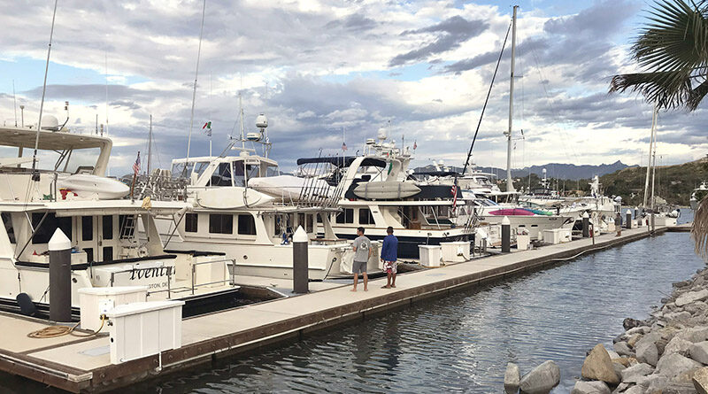
On our 20-mile approach to the mainland state of Sinaloa, the bottom rises to a gentle plane, so expect shrimp boats working at night. Green hills greet our landfall. The narrow dog-leg channel into Mazatlan’s marina district is well marked and usually calm, but in strong north wind a breaking wave may build. Wild parrots flit through coconut plantations, and mangrove estuaries house posh marinas, busy boat yards and exotic jungle scenery.
LA PAZ to TOPOLOBAMPO
This 110-mile crossing from downtown La Paz in Baja Sur to the sea buoy at Topolobampo in Sinaloa starts with 18 miles of crowded but sheltered water – until we depart the 1.5-mile wide San Lorenzo Channel just south of spectacular Isla Espiritu Santo. The open middle of this route runs northeast for 75 miles. If we get bored, we can scan radar for the 700-passenger Baja Star ferry that makes this voyage in summer.
Topolobampo’s sea buoy (about 25°31.40’N by 109°10.82’ W) rides a mile southeast of the marked entrance channel. Let’s hail the Capitania de Puerto on VHF 16 and 22 to announce our arrival and await instructions. Tell them we’re going to Marina Palmira Topolobampo (“Marina Topo”). It’s the only game in town, located nine zig-zag miles beyond the sea buoy, at the northeast end of the harbor’s secondary channel. Dramatic fjord-like peaks and fingers of sandy beach line both sides of our way in.
Don’t miss the Copper Canyon, the best reason to cross to Topolobampo. Book first class round-trip seats on El Chepe locomotive from Los Mochis up to Creel or Divisidero on the rim for jaw-dropping views. Stay two to four days to visit the real Tarahumara village, hike pinon trails and video the canyon’s dramatic depths from the sky tram. We’ll pack jackets because even in summer it can be chilly at this 7,700-foot elevation.
SANTA ROSALIA to SAN CARLOS
This 75-mile crossing is the shortest of the non-stop routes, and at both ends we can get fuel, provisions and usually a marina slip. After fueling and provisioning with Santa Rosalia’s ubiquitous “bolillo” bread loaves, we depart Baja Norte on a course of about 60°T. At 20 miles out, we pass 3.5 miles north of the flat volcanic Isla Tortuga, which is uninhabited and provides no anchorage shelter – so we keep it to starboard. If there are any commercial ships on radar, it might be a gypsum barge being towed from the south tip of Isla San Lucas across to Guaymas, a course roughly parallel to ours but remaining about 10 n.m. distant.
Two landmarks should appear when we’re still 15 n.m. southwest of San Carlos, Sonora. To port, we may spy San Pedro Nolasco Island at eight off. Although uninhabited, it’s a popular fishing and scuba diving excursion. But straight ahead, our horizon is pierced by a distinct twin-pinnacle landmark, Tetas de Cabra. Within a mile north and south of Tetas de Cabra, we find two nice resort marinas with fuel docks and provisions. Unlike the Fonatur Marina at Santa Rosalia on the Baja side, these marinas on the Sonora side have provided shelter from summer storms and maintain a year round gringo boating community.
SAN FRANSQUITO to KINO BAY
This 55-mile crossing (also known as the Midriff Islands crossing) can be accomplished in three island anchorages and four one-day hops that always stay within sight of land. So this crossing is a big plus for folks (usually guests) who suffer from Thalassophobia, the fear of being beyond the sight of land.
San Francisquito in the state of Baja California Norte is a picturesque collection of turquoise anchoring bays – but they’re very remote, uninhabited and have no regular services. So before departure we must have sufficient fuel to make it all the way.
Our first 10-mile leg northwest crosses the Canal de Salsipuedes (Leave if You Can), the steepest and deepest (4,200’ depth) stretch in the Sea of Cortez, so we must navigate it carefully to compensate for strong currents. Keep a camera handy for magnificent sightings – whales, frigates, huge pods of dolphins and manta rays, maybe even a pair of rare Hermann’s Gull.
Once at the south end of Isla San Lorenzo we could anchor below Jack’s Crack, an open roadstead still within sight of San Francisquito. From here, it’s another 10 miles east to Isla San Esteban, anchoring off either side of the southwest sandspit. Fifteen miles farther east at the south end of gigantic Tiburon Island (sacred Seri Indian reservation) is Risco Colorado Bay, where we can anchor overnight below the little Navy building. With good daylight, we can transit narrow Monument Pass north of Isla Turner and head 19 miles east to anchor off the south side of Kino Bay’s uninhabited Pelican Island.
Both beachfront villages of New Kino (3 n.m. northwest of Pelican Island, where most of the retired gringos live) and Old Kino (1.3 n.m. east of Pelican Island) are framed by dust-dry Sonora mountains, but they have lots of trailerable boats, grocery stores, clinics and a Pemex station.
Must see: the Seri Museum’s collection of beautiful Seri basketry and highly sought-after iron-wood carvings. This is also where we might find and hire an indigenous Seri tribal guide with the required permits who can help us explore (a.) the ancient trails and caves on sacred Tiburon Island or (b.) the sandy tidal shores of the adjacent Canal de Infiernillo (Channel of Little Hell).
Crossing the Sea of Cortez transports us into delightfully different worlds. If you find these four crossings helpful, let me know via Katherine@MaritimePublishing.com